Season 2013
Preliminary Results of the Field Season 2013
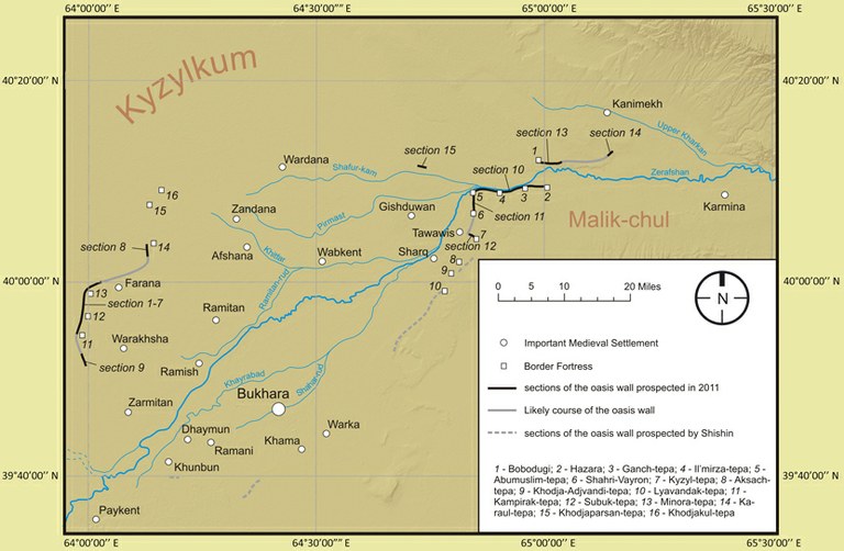
During the 2013 field season of ISAW’s project on the ‘long wall’ of Bukhārā (conducted in co-operation with the Institute of Archaeology at the Uzbek Academy of Sciences and co-directed by Sören Stark and Djamal Mirzaakhmedov) investigations were carried out in two different directions: Firstly, we continued stationary excavations at the site of Ganch-tepa, a mid-sized fortress at the southern bank of the Zerafshan. Secondly, the team resumed investigations at the oasis wall proper by excavating a profile across the oasis wall ca. 200 m west of the fortress Il’mirza-tepa, ca. 5 km west of Ganch-tepa. Works took place from the beginning of July to the end of August.[1]
1. Excavations at Ganch-tepa
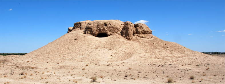
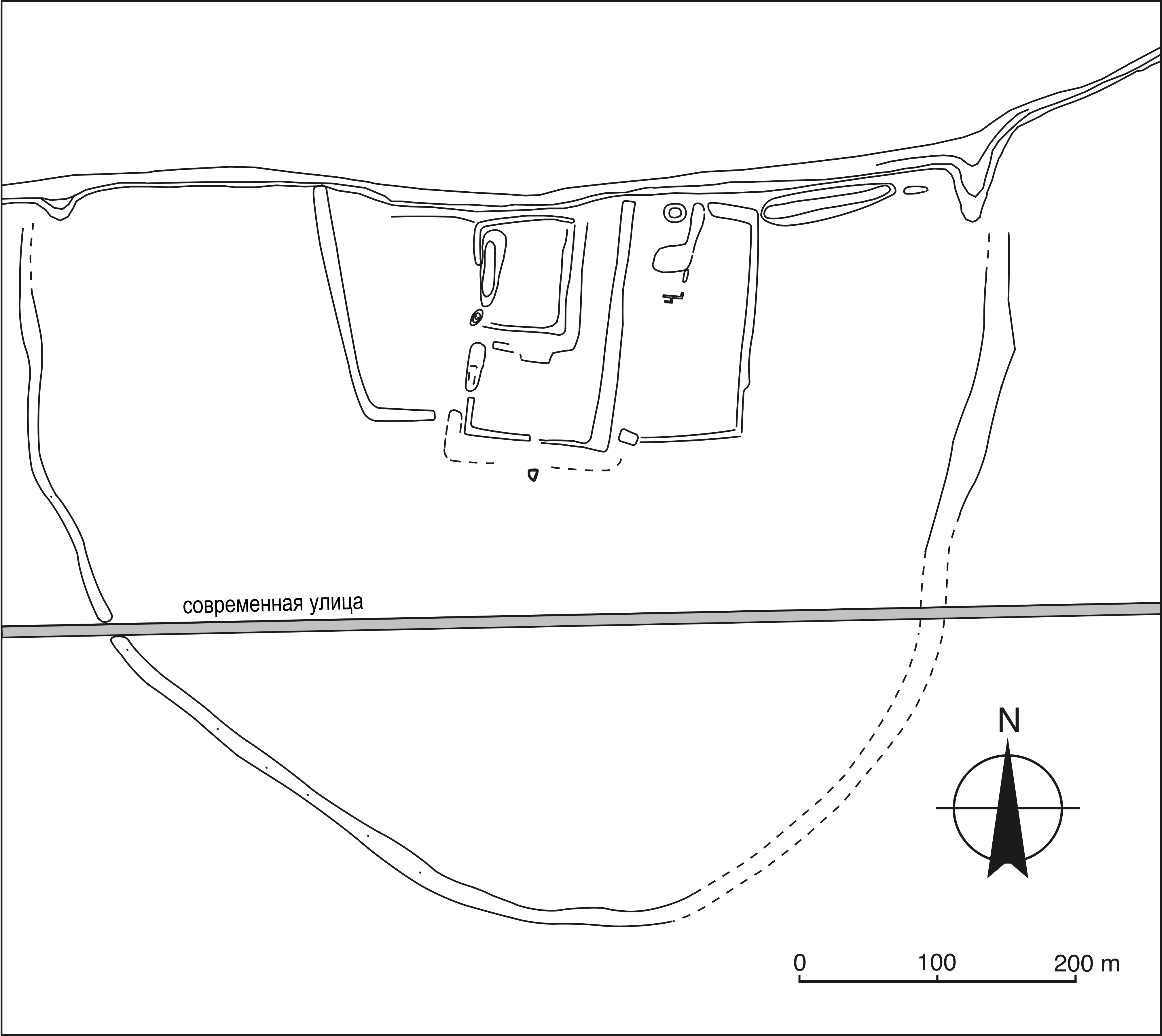
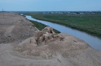 The fortress Ganch-tepa was part of a chain of inter-visible border fortresses, securing the southern flank of a narrow corridor along the Zerafshan River. This area in the very northeast of Bukhārān Soghd was doubtlessly an area of particular strategic importance (fig. 1). The location of the fortress appears well chosen: it towers high above a cliff of the left bank of Zerafshan river and faces, on a slight natural elevation, the Karnāb steppe to the south. From the top of the site, the neighboring fortresses are visible, as well as the entire river oasis to the north. Ganch-tepa guarded access to the waters of the Zerafshan from the steppe and probably a crossing over the river, into the narrow stretch of fertile lands to the north (fig. 2).
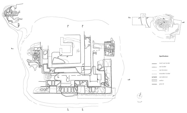
This year’s field season substantially improved our understanding A) of the initial layout of the fortress (fig. 3) and B) of its history between the fifth and the late 8th or early ninth century.
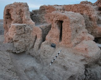
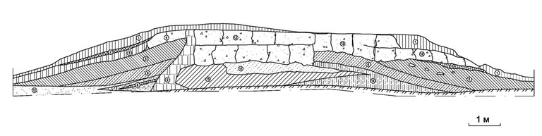
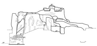 Obviously, the initial fortress was erected on an artificial platform (parts of it were revealed in the southeastern corner of the building). Judging from the remains of its eastern (fig. 4) and particularly its southern façade (fig. 5) – from the northern and western façade only very few traces remained – the fortress appeared in its first phase of existence as a compact and more or less symmetrical castle (called “kūshk” in Persian), with three rectangular towers separated by two curtain walls at each side (fig. 7).
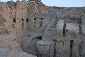
Over the entire façade of the towers sprawl two rows of loopholes in a checkerboard pattern, while the curtain walls contained only one row of loopholes with a ramp-like slope of the façade below (fig. 6). Inside the towers chambers were opened into small corridors, surrounding – most probably – a central courtyard. Corridors and chambers were, apparently, covered by flat roofs resting on wooden beams. Above the roof of the second floor we were able to identify what seems to be the battlements of the original parapet of the building. The entry into the fortress was probably located in the western façade, above and safeguarded by a steep natural slope.
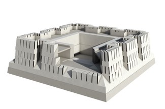
Most of these architectural features are well known from kūshk-castles of Sogdian aristocrats dating to the 5th century – thus confirming our initial dating of the first period of the fortress.[2] However, Ganch-tepa is so far unique as it centers most likely in an open courtyard – and not in a central reception hall (fig. 7). This difference is perhaps due to the fact that the site represents a state fortress and not a fortified aristocratic mansion, which would make Ganch-tepa the first example of such a type of military architecture in Sogdiana.
It seems that this initial fortress of period 1, at some point, fell into disuse. We encountered no traces of a destruction resulting from combat. Instead, there are numerous indications that the building was simply not maintained anymore and, exposed to the elements, it gradually disintegrated. Parts of the building were now used to shelter livestock (as indicated by substantial layers of organic materials on the floor of the first period in the southeast tower). Possibly, the abandonment of the border fortress is related to the beginning of Turkic suzerainty over Sogdiana after 558 CE (but we are still waiting for dates from the C14 samples from this layer).
After this period of abandonment the fortress underwent substantial repair and modification (period 2). At this stage all arrowslits were carefully closed, as were the tower chambers and corridors of the second floor. At the façades, the curtain walls between the towers were closed by brickwork and, finally, the overall façade walls were reinforced by additional brickwork. Probably the total height of the building was also raised. So far this phase of re-construction and modification seems, according to diagnostic ceramic materials from the infilling and the additional brickwork, to date to the 8th century CE.
2. New observations concerning the development of the ‘long wall’ system around Bukhārā and beyond
As earlier fieldwork of our project has revealed, a ‘long wall’ around the delta area of the Zerafshan must have existed as early as the 5th century CE.[3] This finally confirms the long-known (albeit somewhat obscure) notice in Masʿūdī’s Kitāb al-Tanbīh that the ‘long wall’ around Bukhārā was built by a “king of Soghd”, and only restored during the time of al-Mahdī.[4] But does this also apply for the stretches south of the Zerafshan northeast of Bukhārā towards Karmīna, where Ganch-tepa is situated? Or, in other words: Was the ‘long wall’ in this zone constructed simultaneously with period 1 of the fortress (that is ca. in the fifth century? Judging from the specific topographic setting, i.e. the barrier clasping around the fortress to the south at some 15 m distance, this was probably not the case, as this particular configuration thwarts the original defense concept, employing a multitude of arrowslits over the entire façade. As a matter of fact, the barrier would have practically prevented the effective deployment of archers on the 2nd floor because they could not fully engage with any potential enemy approaching the wall. This configuration makes, however, much more sense during period 2, when the defenders in the fortress were apparently only acting from the top of the building (which was probably also somewhat higher than in period 1). From there they could quite effectively control the area in front of the wall, which itself served as a kind of proteichisma. This observation led us to the hypothesis that in this area the ‘long wall’ was built only during period 2 of the fortress.
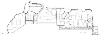
In order to check this hypothesis we excavated one more profile of the ‘long wall’ in this area, ca. 5 km west of Ganch-tepa. Unfortunately, we retrieved no diagnostic ceramics from this small-scale trench. But the profile revealed a building technique using large blocks of “pākhsa” – blocks of rammed earth (fig. 6). This technique is completely different from the one that we encountered in the 5th century profiles near Kyzyl-tepa, in the Bukhārā oasis proper.[5] Interestingly, however, it is in fact very similar to the one known from a section of the oasis wall around Samarqand, the “Dīvār-i Qiyāmat”, that beyond doubt dates to the time of Abū Muslim,[6] that is to the middle of the eighth century CE. This observation further strengthens our hypothesis that the long walls running along the southern and northern banks of the Zerafshān towards Samarqand were first build only in eighth century, obviously at the same time when Ganch-tepa was revived as a fortress.
Of course, such a large-scale initiative cannot be any other one than the “construction” of the Dīvār-i Kanpirak and of a multitude of fortresses under the ʿAbbāsid gouverneur al-Faḍl ibn Sulaymān al-Ṭūsi since late 782/early 783 CE, as reported by the Tārīkh-i Bukhārā.[7] Yet, this important and complex 10th-12th century CE source on the local history of Bukhārā is not entirely correct when it insinuates that this was the first time there was a ‘long wall’ in the Bukhara area – which is, as we have seen above, not the case around the oasis proper of Bukhārā (the Zerafshān delta). It seems to be true, however, according to our new data, for the area along the Zerafshān above the delta opening. Interestingly, we dispose even of a written testimony, which exactly supports this scenario, and which, consequently seems to come much closer to the truth as to what the real novelty of al-Faḍl’s initiative was. This testimony is a very short passage in Abu Saʿīd Abdul-Hay Gardīzī’s Ayn al-Akhbar that has been, so far, largely neglected in the discussion of the history of the Dīvār-i Kanpirak. Mentioning al-Faḍl’s initiative to build a 'long wall' it says nothing about a wall around Bukhārā. Instead we read that during the governorship of al-Faḍl al-Ṭūsi
“a stout wall was constructed between Sogdia [i.e., Samarqand] and Bukhara to protect the people from the Turks”.[8]
This fits exactly our observation that the stretch of the ‘long wall’ south of the Zerafshān, situated east of Bukhārā towards Samarqand, was first built only after 782 CE.
3. Some preliminary historical considerations
These above observations offer a new perspective on al-Faḍl al-Ṭūsi’s wall-building activities in Bukhārā. First of all, all three written sources that give any reason of why the Dīvār-i Kanpirak was built (Tārīkh-i Bukhārā, al-Masʿūdī’s Kitāb al-Tanbīh and Gardīzī’s Ayn al-Akhbar) are – independently from each other – in agreement that it was meant to offer protection from the “Turks”. So we should take this information seriously. But does this refer to the general menace of raiding parties from the Qypchaq steppe in this area? In light of the new data it seems that we have to understand this grandiose undertaking in a more specific historical context: namely in the light of the revolt of Muqannaʿ, which had posed a serious danger to ʿAbbāsid rule over Mā warāʾ al-nahr in the years just prior to 782 CE. One of the main reasons for the troubles of the central government was the fact that Muqannaʿ and his field captains succeeded to ally with various Turkic warlords and even with the Qaghan of the Qarluq (beyond Chāch, i.e. present-day Tashkent) – the consequences of this alliance are vividly summarized in the Tārīkh-i Bukhārā:
“Muqannaʿ invited the Turks and permitted them (to take) the life and possessions of the Muslims. Many troops came from Turkistān in the hope of plunder. They pillaged the districts and carried the women and children of Muslims into captivity, and killed (others)”.[9]
Perhaps, one of the major meeting points of these “Turks” before they started their raids on Bukhārā proper was a place called Kūk or Kūk-shībaghan, mentioned by al-Qudāma (second quarter of the 10th century) as the place where the “king of the Turks” (malik al-Turk) assembled his troops before sending them out for raiding.[10] Interestingly, this place has been – long ago already – identified with the archaeological site of Hazara, situated exactly in this narrow river corridor east of Bukhārā towards Karmīna.[11] In order to secure communication between the two most important metropolitan regions in Mā warāʾ al-nahr, Bukhārā and Samarqand, it must have been of vital interest for the ʿAbbāsid government to secure control of this particular corridor, and this was in all likelihood the reason why al-Faḍl was not content with only restoring the old oasis wall around the delta area of Bukhārā, but why he started to extend this long wall system further eastwards, thus protecting the major line of communication with Samarqand Soghd in general, and the vulnerable area around Hazara in particular. Perhaps, the large-scale project to build and re-build territorial barriers was also seen by the authorities as a mean to police a restive region, where an endless succession of revolts must have retained the cities to impose control on their hinterland.[12]
At this point it is difficult to estimate how much further east this system was planned to run, and how much of that was actually built – recent traces of the walls don’t reach further east than the fortress of Hazara. However, it seems noteworthy that archaeological surveys in the 1960s revealed traces of an extensive territorial barrier system also northeast, north and northwest of Samarkand (roughly between present-day Jizzakh and the village of Mitan (northeast of early medieval Ishtīkhan).[13] Generally it is assumed that this system dates back to the pre-Muslim period,[14] but in fact there is no evidence for such an assumption. Instead, one may wonder – most cautiously at this point – whether at least parts of these traces in fact constitute eastern sections of al-Faḍl al-Ṭūsi’s “stout wall” between Bukhārā and Samarqand.
Literature
Barthold 1977: W. Barthold, Turkestan down to the Mongol Invasion (London 4th ed. 1977)
Bosworth 1989: C. E. Bosworth, The History of al-Ṭabarī. Vol 30: The ʿAbbāsid Caliphate in Equilibrum (Albany/NY 1989)
Bosworth 2011: C. E. Bosworth, The Ornament of Histories: a history of the Eastern Islamic lands, AD 650-1041. The Persian text of Abu Sa'īd 'Abd al-Hayy Gardizi (London 2011)
Carra de Vaux 1896: B. Carra de Vaux. "Maçoudi. Le livre de l'avertissement et de la revision. Traduction par B. Carra de Vaux." Imprimerie nationale.
Crone 2012: P. Crone. The Nativist Prophets of Early Islamic Iran. Rural revolt and local Zoroastrianism (Cambridge et al. 2012).
Frye 1954: R. N. Frye, The History of Bukhara. Translated from a Persian Abridgement of the Arabic Original by Narshakhī (Cambridge/Mass. 1954)
Karev 2002: Y. Karev, La politique d’Abū Muslim dans le Māwarā’annahr. Nouvelles données textuelles et archéologiques. In: Der Islam 79 (2002), 1- 46.
al-Masʿūdī 1894: Kitâb at-tanbîh wa’l-ischrâf, auctore al-Masûdî (ed. M. J. de Goeje = Bibliotheca Geographorum Arabicorum 8) (Lugdunum-Batavorum 1894)
al-Qudāma 1889: Kitâb al-Kharâdj, auctore Kodâma ibn Djaʿfar (ed. M. J. de Goeje = Bibliotheca Geographorum Arabicorum 6) (Lugdunum-Batavorum 1889)
Большаков 1956: О. Г. Большаков, Заметки по исторической топографии долины Зерафшана в IX-X вв. In: Краткие собщения Института истории материальной культуры 61 (1956), 17-23.
Массон 1950: М. Е. Массон, К периодизации древней истории Самарканда. In: Вестник древней истории 1950/4 (1950), 155-166.
Мирзаахмедов/Штарк 2012: Д. Мирзаахмедов/С. Штарк, Работы Узбекско-американской экспедиции по изучению оазисной стены Бухары Кампир-Девор. In: Археологические исследования в Узбекистане 2010-2011 года 8 (2012), 191-202
Мухамедов 1972: X. Мухамедов, Новые участки Канпир-девора древнего Согда. In: История материальной культуры Узбекистана 9 (1972), 131-146.
Семенов 1996: Г. Л. Семенов, Согдийская фортификация V-VIII веков (Санкт-Петербург 1996)
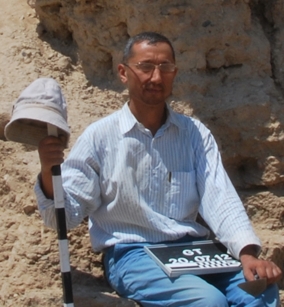
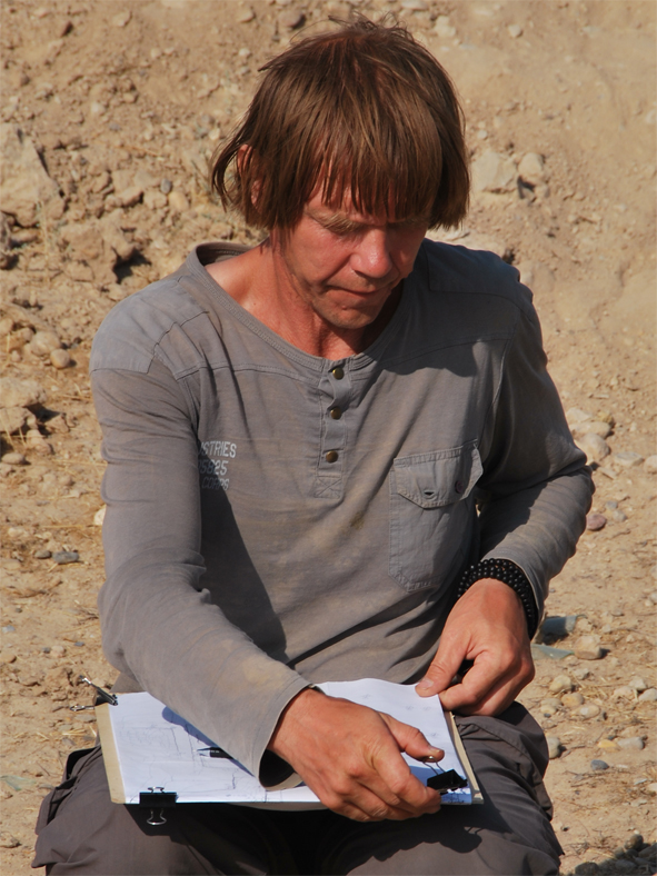
[1] Works were directed by Djamal K. Mirzaakhmedov and Sören Stark. Members of the field team: Sören Stark, Bakhtiyar Abdullayev, Sirodj Dj. Mirzaakhmedov (archaeologists), Stanislav Gil’ and Ol’ga Gil’ (architects). Once more we greatly enjoyed the food prepared by Roza Ibrahimova. Our thanks to all of them for their collaboration!
[3] Мирзаахмедов/Штарк 2012, 195-201.
[4] al-Masʿūdī 1894, 65. French translation: Carra de Vaux 1896, 96.
[5] See Мирзаахмедов/Штарк 2012, fig. 5.
[6] For a summary on this monument and Abū Muslim’s activities in Samarqand see Karev 2002.
[7] According to al-Iṣfahānī’s Tārīkh sinī mulūk al-arḍ wa-al-anbiyāʾ al-Faḍl had arrived as gouverneur in Khorāsān in October 782 CE (Bosworth 1989, 101 n. 385).
[10] al-Qudāma 1889, 203; see also Barthold 1977, 99. At least by 777-778 CE Turkic raiders seem to have been the main danger for ʿAbbāsid rule in the Bukhārā area – see Crone 2012, 113.
[12] Crone 2012, 120. As Crone points out, in the ca. 30 years between the ʿAbbāsid revolution and the end of the revolt of Muqannaʿ Bukhārā saw four major revolts.
[13] Мухамедов 1972. Some parts of this barrier system still exist to the northeast of Samarqand.
___________________________________________________________________________________________________
© Sören Stark update: 21-04-2014