Connecting the Ancient World: Pleiades and Itiner-e
The study of the ancient world in the 21st century increasingly depends on digital work that connects a variety of information, opening up new avenues for research, teaching, and exploration. The Institute for the Study of the Ancient World has, from its founding, embraced the digital humanities, training our doctoral candidates in its methods and collaboratively producing innovative digital resources and tools. One example is the institute’s long-term support for the Pleiades gazetteer of ancient places for which I serve as Managing Editor. Today, I’m excited to highlight collaboration between Pleiades and Itiner-e, a groundbreaking digital atlas of roads in the Roman Empire that was recently featured in the New York Times and other media.
Itiner-e was developed by Tom Brughmans (Aarhus University), Pau de Soto Cañamares (Universidad Autònoma de Barcelona), and Adam Pažout (Universitat Autònoma de Barcelona) in collaboration with a large international team of scholars. The website allows users to view, query and download information about ancient Roman roads, bringing together the most comprehensive and detailed dataset of Roman roads ever published. Each road segment included in the atlas has a unique Uniform Resource Identifier that allows it to be cited and linked by external resources. The site also includes a route-finding tool to explore travel itineraries and times in the ancient world. The co-directors and their core collaborators announced the project in November 2025 via a peer-reviewed article in the journal Nature Scientific Data. Itiner-e is a monumental achievement, and the project team has coordinated with scholars around the world to ensure that their work and the data in other systems and publications are mutually reinforcing.
This coordination and interdependency is particularly true for ISAW and Pleiades. Over a year ago, the Itiner-e team contacted me about their use of Pleiades data in Itiner-e and invited me to participate in a pre-launch review and workshop in Aarhus in late 2024. The resulting, on-going collaboration is more than just a friendly exchange of ideas; it’s a technical partnership that enriches both resources.
Itiner-e regularly uses data from Pleiades’ nightly exports to generate its base map, ensuring that its representation of Roman roads is clearly contextualized for users with respect to the ancient settlements cataloged in Pleiades. Going further, the Itiner-e team calculates the proximity of their road segments to Pleiades places and publishes these connections in their own data.
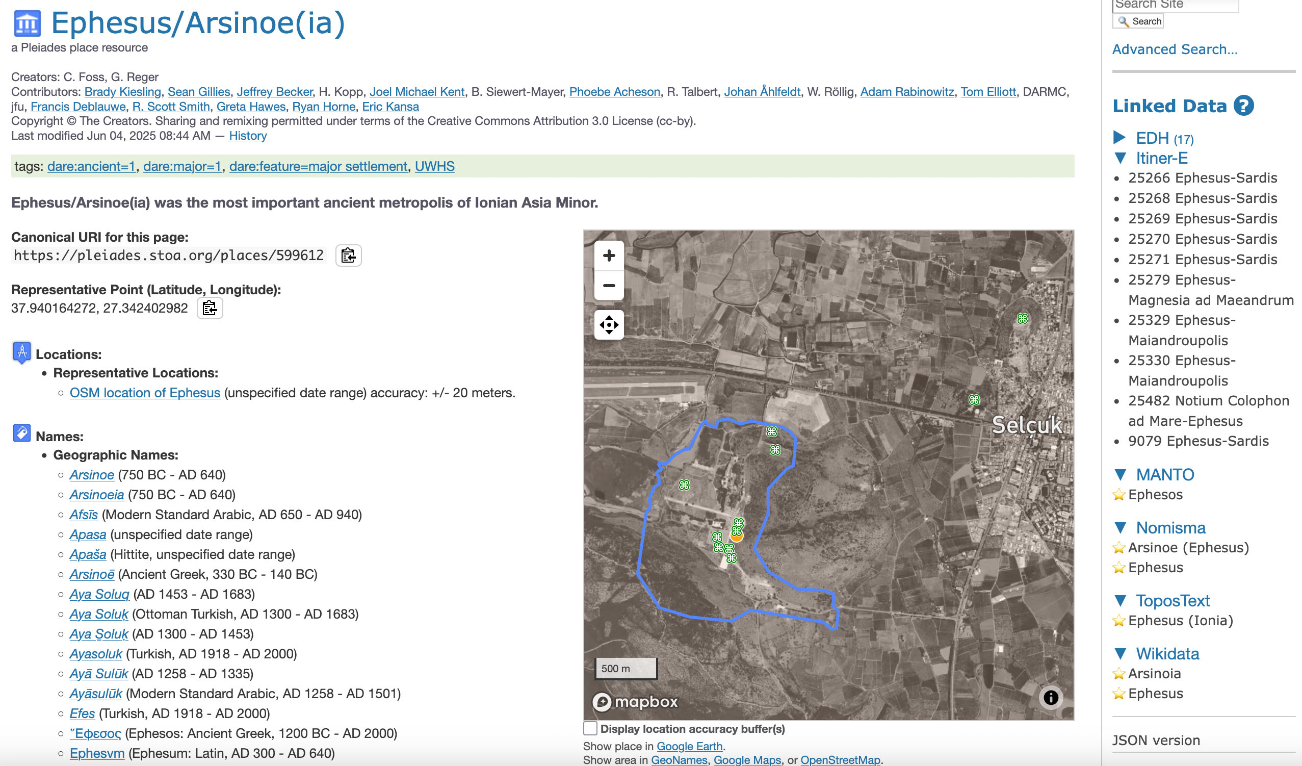 Screen capture of Pleiades page for Ephesus showing Linked Data Sidebar (select to enlarge)
This is where a relatively new feature in Pleiades — inspired by discussion at the Aarhus workshop — comes in: the Linked Data Sidebar. Appearing on the right-hand side of many Pleiades place pages, this sidebar shows users the other major online resources that link to the Pleiades entry they are viewing. Thanks to collaboration with the Itiner-e team, Pleiades can use their data to show a direct link from a Pleiades place to the nearby Roman roads documented in Itiner-e.
Screen capture of Pleiades page for Ephesus showing Linked Data Sidebar (select to enlarge)
This is where a relatively new feature in Pleiades — inspired by discussion at the Aarhus workshop — comes in: the Linked Data Sidebar. Appearing on the right-hand side of many Pleiades place pages, this sidebar shows users the other major online resources that link to the Pleiades entry they are viewing. Thanks to collaboration with the Itiner-e team, Pleiades can use their data to show a direct link from a Pleiades place to the nearby Roman roads documented in Itiner-e.
For example, if you visit the Pleiades page for a major Roman city like Ephesus, the Linked Data Sidebar will show you links to road segments in Itiner-e that passed near the ancient city. This creates a seamless connection, allowing a student or researcher to move instantly from the geography of a place to the transportation networks that connected it to the wider Roman world.
The Pleiades Linked Data Sidebar currently includes inbound links from Itiner-e, Wikidata, and ten other key digital resources for the study of antiquity. You can learn more about all these important sources on the Pleiades Linked Data Sidebar documentation page. Work is on-going to bring additional datasets into the sidebar, and changes are announced on the Pleiades News Blog.
The integration of two expert-curated datasets is a perfect example of the value of Linked Open Data. By building these digital bridges, we create a richer, more interconnected picture of the ancient world, benefiting everyone from the curious browser to the dedicated scholar. We congratulate the Itiner-e team on their successful launch and look forward to our continued collaboration.